 COSMIC
PATTERNS SOFTWARE, INC.| WWW.ASTROSOFTWARE.COM
COSMIC
PATTERNS SOFTWARE, INC.| WWW.ASTROSOFTWARE.COM
| PRODUCTS | SERVICES | INFORMATION/EDUCATION | COMPANY | PURCHASE | CONTACT US |
|
KEPLER SCREENS AND CHARTS: CHART WHEEL SAMPLES: OTHER EXCITING FEATURES: |
| |
|
 Kepler can
be used by people with any level of experience, from novice to professional.
Novices can stick to the basics, experts use the advanced features. Complete
atlas included. Kepler can
be used by people with any level of experience, from novice to professional.
Novices can stick to the basics, experts use the advanced features. Complete
atlas included. |
|
An AstroMap is a wonderful tool for astrologers and students of astrology because it shows all places where an astrological influence exists by drawing lines on a map. One problem with AstroMaps is that you cannot see exactly how far from the line the astrological influence extends - until now! Kepler has overcome this problem with its unique AstroMapping capabilities that show you how far the astrological influence extends. You can produce AstroMaps in Kepler with blue-shaded orbs. These blue-shaded show exactly how far the astrological influence extends. Also
available in Kepler are Treasure Maps. Treasure Maps, like
AstroMaps with blue-shaded orbs, show how far an astrological
influence extends, but go yet another step: with a Treasure
Map you can see precisely what areas are highlighted for areas
of interest, such as Love and Romance, or Vocation and Career!
Treasure Maps contain areas that are shaded from pale yellow
to bright red, showing how strong the astrological influences
are. Treasure Maps are not only beautiful; they also provide
you and your clients with the information you want: you can
see what areas are most conducive to the things that interest
you most. Treasure Maps utilize very sophisticated astrological
techniques that provides you with accurate and useful information.
You can also customize the astrological influences that are
analyzed to produce the Treasure Map and other AstroMaps in
Kepler.
OTHER EXCITING FEATURES OF ASTROMAP: What do we mean by "appropriate AstroMap style"? When selecting any AstroMap, you have options to select any country, continent, or the entire world. You can zoom in or out, or scroll, and you can also place a specific town or city in the center of the map. Amazingly, as you zoom in, Kepler automatically inserts more towns in your map so that you can see smaller towns and cities on your map as you zoom in. Kepler can also automatically add more astrological influences as you zoom in as well. These "auto-adjusting" features make it possible for you to obtain the information you want very quickly and easily. When viewing a large area, such as the entire world, it is best to pick out the most conspicuous areas, those areas that have conjunctions and oppositions to the Asc and MC. When
viewing a smaller area, such as a specific country, you are
zooming into a smaller area and can see the other astrological
influences, such as other aspects and midpoints to the Asc
and MC. Kepler automatically selects an appropriate level of
detail of the map for you, and allows you to easily change
it as well, giving you great ease of use as well as flexibility. MORE COLORFUL AND USEFUL ASTROMAPS:
Map Guides: Kepler has the ability to print a listing of what the lines in an AstroMap mean. You can give this to your customers (and study it yourself as well, of course) to learn what all those lines and colored areas on your map mean! Astrolocality Report: This feature is very handy, unique and an awesome feature of Kepler. While an AstroMap is viewed on the screen, you can click on any point on the map. The interpretation for that specific point is then displayed on the screen. The Astrolocality report is an astrological analysis of what you are likely to experience in the cities and towns that you selected is given. The astrological influences that are strongest begin with three asterisks (***) and appear at the beginning of the report. Next are the influences with one asterisk (*), which are strong but not as important as the astrological influences that have three asterisks. The astrological influences with no asterisks are at the end of report and are weakest, but they are also significant in your life. The AstroLocality Report uses astrological methods developed through the latter half of the 20th century, and refined through extensive research, some of which is described in the book "AstroLocality Magic". Technical Features of AstroMaps: There are 2 ways that astrologers calculate AstroMaps: in longitude and in mundo. A discussion of these technicalities would be quite lengthy, so weI won't get into it now, but suffice it to say that astrologers typically make calculations in longitude; that is how birth charts and the vast majority of astrological analyses are done. However, some astrologers prefer to calculate AstroMaps using in mundo positions. In Kepler Version 4.6 you can easily select either in mundo or longitude positions for traditional AstroMaps. For AstroMaps with blue-shaded orbs and Treasure Maps you must use longitude. In Kepler we made it much easier to switch between in mundo positions and longitude positions. If using in mundo positions, you can also include aspects and midpoint structures. An AstroMap with in mundo aspects is very interesting; the planetary aspect lines criss-cross each other in the map rather than being mostly parallel. Distance Between any point on the Map: If you left click on the AstroMap, an ellipse will be drawn and the size of the ellipse will be shown in the upper right corner of the screen. This ellipse allows you to see how many miles and kilometers nearby areas are from any point. If you left click again, a line will be drawn between the previously selected point and the new point, and the distance between two points is given. This feature is very handy when you are planning to travel and want to know the distance between cities in each specific georaphic areas. Other AstroMap Styles: You can also produce Geodetic Reference and Geodetic Planet AstroMaps, Zodiac Sign AstroMaps, and Local Space and Horizon AstroMaps with the Kepler program. |
||
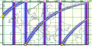 Blue-Shaded
Orb AstroMap: AstroMaps
for the 21st Century! AstroMaps are wonderful. You can
see lines going through the maps that show where a particular
planetary planet influence is very strong for you. However,
it is not possible to see exactly how far the influence
extends
away from the line, so you cannot determine exactly what
areas are affected by the lines. Now the Kepler program
allows you to print AstroMaps with a blue-shaded area surrounding
the aspect line so you can see what area the influence
extends
too. You can change the orb, if desired, as well. These
new AstroMaps with blue-shaded orbs make all other AstroMaps
obsolete. The AstroMap below shows an AstroMap for Mother
Teresa in Europe.
Blue-Shaded
Orb AstroMap: AstroMaps
for the 21st Century! AstroMaps are wonderful. You can
see lines going through the maps that show where a particular
planetary planet influence is very strong for you. However,
it is not possible to see exactly how far the influence
extends
away from the line, so you cannot determine exactly what
areas are affected by the lines. Now the Kepler program
allows you to print AstroMaps with a blue-shaded area surrounding
the aspect line so you can see what area the influence
extends
too. You can change the orb, if desired, as well. These
new AstroMaps with blue-shaded orbs make all other AstroMaps
obsolete. The AstroMap below shows an AstroMap for Mother
Teresa in Europe. 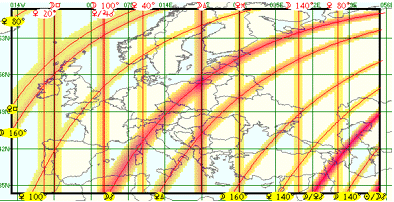 Treasure
Maps:
Treasure
Maps: